What about CB-CIS
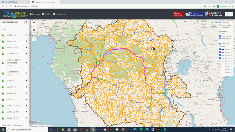
CB-CIS (from English: Congo Basin Catchment Information System) is a knowledge interface that provides information of high scientific scope and in near real time on the structure, processes and functions of water resources at the scale of sub-watersheds , better “water resources management unit”, as well as on the impacts of changes in the physical environment and society.
CB-CIS is a planning tool that sectors the Congo Basin into water resources management units and makes available the appropriate information necessary for Integrated Water Resources Management at the scale of these units.
CB-CIS provides consistent guidelines to facilitate community resilience to the adverse effects of environmental chang .
CB-CIS aligns in support of the 2020-2030 strategy for the water sector in the Democratic Republic of Congo, and the 2063 agenda of the African Union in the water sector.
CB-CIS is the first information system on water resources in the Congo Basin.
Content and operationalization of CB-CIS
The current version « CB-CIS v1.0 » presents 1740 water resources management units that have been partitioned for the entire Congo Basin based on a multi-level criterion, including topographic gradient, inclusion of socio-economic and anthropogenic systems, and hydronymy.
The interface .CB-CIS v1.0 displays global thematic layers, administrative boundaries, and nine classification levels of the Congo Basin hydrographic network. For each water resources management unit, the user has access to information grouped into seven themes below :
-
Administrative identification and regional classification of the unit ;
-
Climate;
-
Physiographic characteristics and land use ;
-
Hydrology ;
-
Risks (flooding, stress, water quality and pollution) ;
-
Potential and uses of water ;
-
Other information and external links.
Profit with CB-CIS
The benefits provided by CB-CIS are enormous, from a scientific and management point of view. It allows to :
Improve scientific knowledge on the dynamics of the Congo Basin water resources system, their distribution in time and space, and the interactions to which they are subject ;
Provide a framework of measurements to guide hydrological investigations, and make information available where ground measurements are non-existent or almost impossible to obtain, which will allow hypotheses to be verified and the development of new predictive and robust approaches to address the questions water management under conditions of environmental change.
Inventory the resources available at the local scale or small management unit, evaluate their potential or their economic value, and direct investments to improve access to water resource services, and carry out analyzes on regions according to their potential. and also their sensitivity to natural and anthropogenic disturbances (a guarantee of rational practices for conservation and management of water resources).
Provide a framework for dialogue between stakeholders for water management by reduced unit or sub-basin, where water management committees at the sub-basin scale are established and play a leading role in the supply of services and resource conservation.
Help the parties establish a common language and a community of practice for common management and planning issues in the Congo Basin.
Provide reliable answers to current issues on water security in the Congo Basin, in particular: water transfer, climate change and the risks of natural disasters, water quality and pollution waterways, and improved access to water resources services (agricultural, commercial, domestic, energy, environmental and industrial needs), while providing consistent guidelines to enable societal resilience.