The Congo Basin Water Resources Research Center (CRREaC) calls on Congolese policy makers to act urgently to prevent the spread of the pollution disaster.
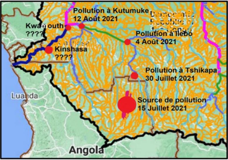
Since the beginning of August 2021, the riparian communities in the Kasai River Basin, along the Tshikapa and Kasaï Rivers, have been experiencing an unprecedented environmental and human disaster, due to water pollution from mining activities in the headwater catchments located in Angola. The mining schemes identified in these areas include the Luo, Camatchia-Camagico and Catoca diamond mining in the Angola part of the Kasaï River Basin.
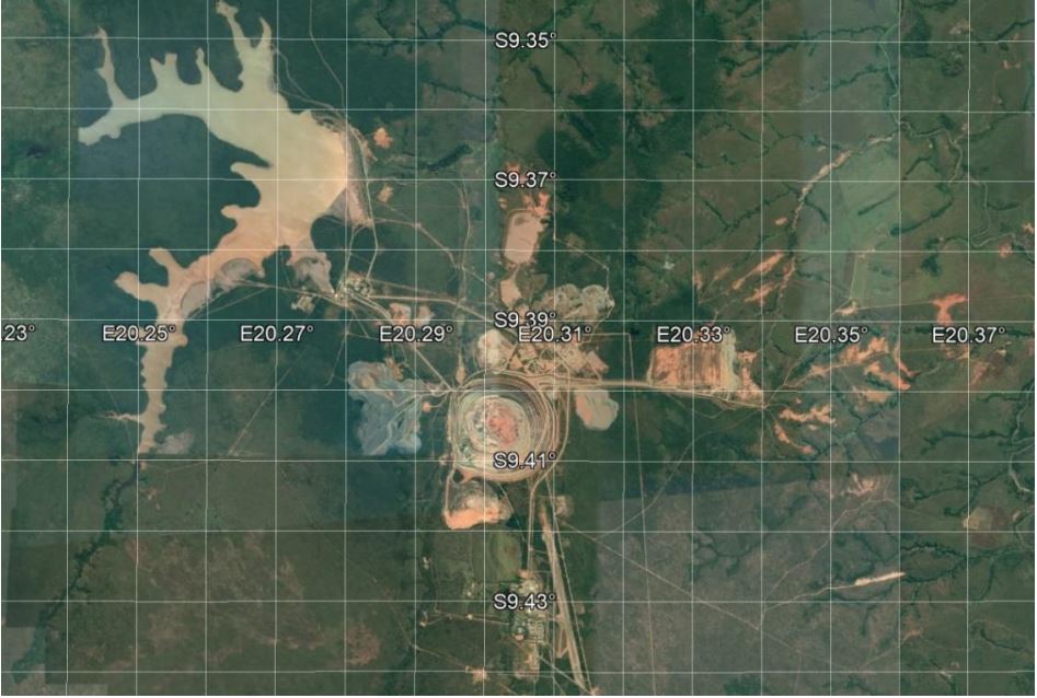
On the basis of the Sentinel images published by Visio Terra (Equipe Sentinel Vision, EVT-919, 2021) and our preliminary investigations from riparian communities, this pollution has been observed since 15 July 2021 from the source in the Angola part of the basin and would have taken 15 days to reach the city of Tshikapa, and 21 days for the city of Ilebo in the Democratic Republic of the Congo (DRC).
In addition, the information obtained from the Congo Basin Water Resources Research Centre (CRREBaC) flow monitoring station located along the Kasaï River at the city of Kutumuke in DRC, the pollution was observed at this point as of 12th August 2021.
This
station is located only 140 km from main stem of the Congo River at
the city of Kwamouth, there is a possibility for this pollution to
reach the Congo River, in a very short time. The town of Kinshasa
being located at 190 km downstream the city of Kwamouth, the spread
of this pollution is to be feared.
The
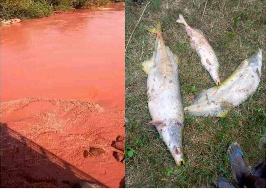
immediate consequences of this disaster recorded so far include water
pollution, poisoning and loss of aquatic fauna and flora, waterborne
diseases for riparian communities, disruption of fishing and
navigation activities, and lack of access to domestic water and
recreation services.

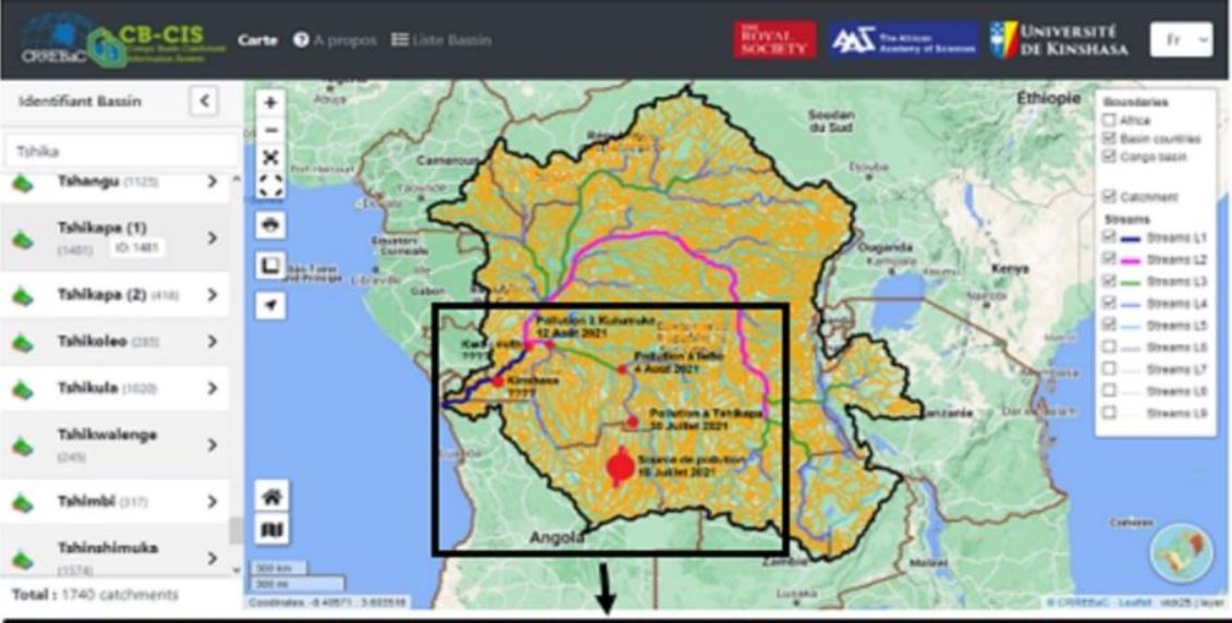
Over the past years, CRREBaC has put in place monitoring and planning tools, useful for integrated water resources management in the Congo Basin. One such tool is the CB-CIS, a knowledge-based interface that provides high quality information on the structure, processes and functions of water resources at the catchment scale, as well as impacts of change in the physical environment and society.
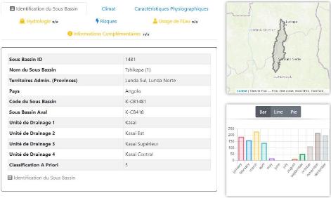
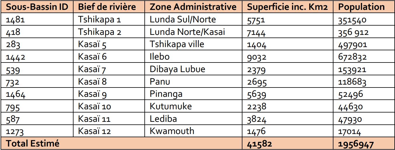
La figure ci-après identifie la source de la pollution à partir de l’outil CB-CIS, qui fait référence au sous bassin ID 1481, situé dans les provinces de Lunda Norte et Lunda Sul en République d’Angola.
It was also possible to identify in CB-CIS the propagation of pollution for the downstream catchments, as presented in the figure and table below. Over two million (2,000,000) people are exposed to the risks of water pollution as identified from CB-CIS.
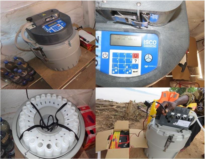
Since 2017, CRREBaC has been monitoring water flow (water quality and quantity) from its station along the Kasai River at the city of Kutmumuke, which automatically collects daily samples. This station implemented under the Royal-Society DFID funded research programme is the only complete station on the Kasai River that can be used to date to assess the situation before and after this tragedy. These measurements will need to be completed with other measurements upstream and downstream of the CRREBaC station, to assess the level of risk, and establish a response plan that will also support decision-making for sustainable water management in the Kasai River Basin.
In view of the above, there is an urgent need for a monitoring strategy to assess the damage, and to propose mitigation and remediation measures. This includes the following actions:
Ensure that there is immediate cessation of pollutants discharge into rivers from the source in Angola;
Establish a plan for hydrodynamic measurements and sampling including water quality, sediment and aquatic biodiversity samples upstream and downstream of the CRREBaC station, and based on the exposed catchments as identified in the CB-CIS to determine the extent of the pollution damages;
Conduct as soon as possible a targeted field data collection campaign and laboratory analyses based on the above-mentioned hydrodynamic measurements and sampling plan;
Assess the socio-economic and environmental impacts of pollution and propose mitigation and remediation measures;
Strengthen the operational capacity of the CRREBaC monitoring station and duplicate this scheme in other sensitive areas, including mining and industrial areas, areas with high population concentration, and areas of unique biodiversity such as the Malebo Pool, which suffers pollution from anthropogenic activities throughout the Congo Basin;
Implement an accelerated training of trainer’s programme to increase the technical and operational capacity of the services involved in monitoring water-related disaster risks;
Implement a communication strategy to better inform theriparian communities for awareness raising and safety.